Trip to the Abaco's in the Bahamas 2012
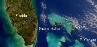
Mar 24 Update: - Just got another update form Clayborn Young. it states: "Florida, Okeechobee Waterway Lock Closure, Update – MNN030712 I can tell you that Deb and I won't be coming back early unless there is a hurricane on it's way. Otherwise we are headed for a leasurly cruise down the Keys and I'll be you can already guess that we will be sweating a bit in Key West. Then all we have is a sweet sail back home. Mar 23 UPDATE: - I've changed a number of sections of this announcement and added the route planning information. If you haven't got your Customs Sticker yet - you really need to get on it. We've only got a month and a half left and we will be underway! Feb 25 UPDATE: - I copied this off of Claiborne's website. Looks like we will be able to cross the Okeechobee in May but will have to head back around south on the way home. Oh darn. We'll have to head back through the Key's again. Can you see the disappointment on my face.... ha, ha. Can't wait to see the Keys again after a month in the Bahamas. Anyway, here is the info on the closing of the waterway. Looks like they will be closed from May 14-July 14. Claiborne: Heading to the Bahamas Announcement Deb and I are planning a trip to the Bahamas on "Freedom" in May and June. We've invited anyone who would like to go on their boat especially those who haven't done the trip in the past and want to cross with a group. I will describe what I will be doing for preparation although I stress that each captain must take into account their own vessel and their experience. It is totally your decision whether to go or not along with what preparations you need/should/want to make. I'll try my best to make this comprehensive but again, I don't know your boat. On top of that, even though I will be taking enough tools to rebuild almost everything on the boat along with my spares - you should act similarly since you know your boat better than anyone else. With that disclaimer stated, it should be an absolute blast in May/June because we shouldn't have fronts to really be concerned about and it should be too early for tropical storms. The weather should be fine and I know the water will be beautiful. I also want to add that the last three crossings Deb and I have done, we did by ourselves. We've been further offshore in the Gulf of Mexico so we simply pick a good weather window, prepare our boat properly, and get out there. This is the overview
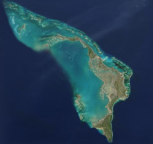
of where we are going - This is where we will be spending most of our time - northeast side- |
|
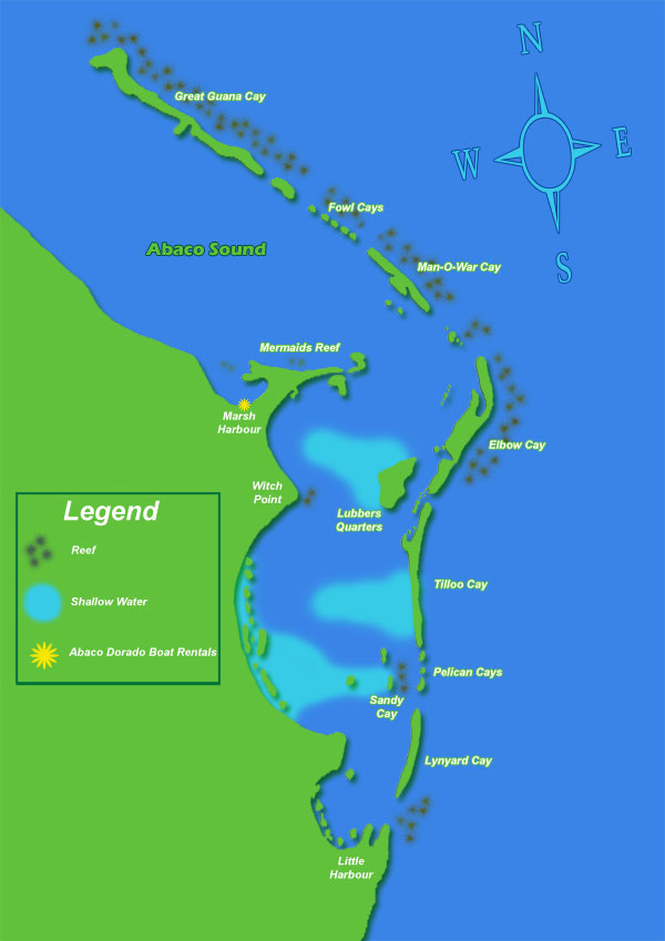
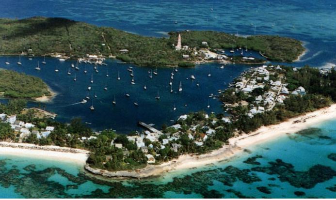
Let's start with the plan: We plan on being to West Palm by May 10th. If the weather is perfect we will anchor there and leave early on May 10th. Otherwise we will stop at Lake Worth since there is a good dinghy dock with access to stores and restaurants. Lake Worth will be a good place to weather any front if necessary then we will pre-position the night before we leave to West Palm. It is always a risk for people who want to visit you to book an airplane since you never know about the weather or if you will have a boat problem. As long as they understand this, we figure it will be safe for people to book as early as June 25th to arrive in Marsh Harbor. This will give us 15 days to make what could be a 4 day trip over to Marsh Harbour. Reality is, once we are on the Bahamas bank then long trips are over and our goal will be to check in at Spanish Cay (pronounced Key) then get out and do some snorkeling, fishing, happy hours on boats, impromptu get together's, walks on the beach, find shells, you get the idea! In other words, we won't make Marsh Harbour in 4 days but we could. My idea for the trip is to help those who haven't crossed before or gone to the Bahamas to provide some education and direction before the trip, cross as a group, get everyone checked in to Bahamas Customs. Next I see us making some group decisions about where we can all group up during the trip to enjoy some common things such as having a Nipper at Nippers on Sunday afternoon - a tradition in the Bahamas or climbing the light house at Hope Town, touring at Pete's Pub, not to mention probable live music at Green Turtle Club, fun in Marsh Harbour. On top of these possible group activities, I fully expect for and encourage people to break off and go snorkeling, diving, fishing, have fun with each other or people that flew in. In other words, we won't be "joined at the bilge." Currently we are planning on starting back to the States around June 11 or 12. Since the Okeechobee route will be closed, we will be going back by way of West Palm so you can check in there if you need to. If you have the local boaters option, you will not need to check in "in person." Hope Town is one of the settlements that you will want to visit. You can see the mooring field below along with the lighthouse.
|
Now for the list that I'll be filling out directions for over the next few weeks. Passport - If you don't have one for everyone that will be going on your boat, get started now and get them. FCC License - The FCC requires that you have a station license if you transmit in another country i.e. Bahamas. I have one and the link takes you to how I did it. With that said, I think I'm the only one that goes over that does have a license. Customs Sticker - You will need a sticker from Customs which you can order on-line. It takes a couple of weeks to get it so get started right away. Local Boaters Option - LBO - If you plan on going to the Bahamas frequently, (key word plan) and I do, then you can get the local boaters option which will allow you to call in when you return from the Bahamas instead of appearing in front of a Customs officer. I'm planning on doing this in the next week and will document the process for you. Explorer Charts - EVERY Cruiser will say that the explorer charts are the BEST. I agree and you will need the set for the Near Bahamas. Order them NOW so you can study them and read about your trip. You may also want to order a guidebook for the Bahamas and I personally like the one by Steve Dodge. I have an older one but it is very good. You may also want to read about our trip to the Abaco's two years ago. We hit most of the good spots and will again. Bahamas Check In - What to expect Dinghy Docks - They are abundant and the locals use their boats as cars going from island to island. This won't be an issue and are documented. However, your dinghy is now your family car and will get you around everywhere. Make sure you have patches and your engine works well before you leave. Get an anchor and a long line. If you are going to snorkel from it, make sure you can get in and out - ladder. Flags - You will need a US flag that will be flown on your aft stay or a pole if you have one. You will also need a quarantine flag that will be flown from your starboard spreader until you check in. Once you check in you will replace your quarantine flag with a Bahamas flag. It will fly until you leave Bahamas waters when you will put your quarantine flag back up for entry into the U.S. Food - We'll probably take 3-4 weeks of food with us. That said, shopping at Green Turtle, Marsh Harbour, Hope Town is all pretty good. Just expect to pay about 25% or so more for everything. They have to ship it by boat so their costs are greater and taxes are included in the price verses the add on we have in the states. One thing you have to consider is you will be getting together on other peoples boats for happy hour. Take your favorite recipes along with the ingredients. Diesel and Gas - Pretty easy to get but expect to pay 30+ percent higher. Don't be surprised if it isn't 6 bucks a gallon or higher by summer. I usually take a 5 gallon can of diesel on the rail along with a 5 and 2 1/2 gallon can of gas. Diesel is for my security blanket - just in case. The gas is for my Honda Generator and the dinghy. Propane - Easy fill up of propane at Marsh Harbour at the hardware store where you drop off a can then pick it up later. The cost will probably be twice what you pay in the states. I'll be taking my spare BBQ grill tank so I have 3 tanks on board. Snorkel Equipment - Take what you would like. We have one person (Bill) going who is an expert diver and snorkel guy. He will be in the water every day. On top of that, he's a great guy so if you are new to snorkeling or diving he'll probably help you out. Fishing - You will receive a fishing license for the boat when you enter. It is part of your Customs process. If you like to fish, take your equipment. If you want to spear fish, you have to use a pole spear. Flares - You should have flares already but make sure they are current. You will be offshore and if something goes wrong you will want them. Spares - You have to decide what to take. If you don't have it and it breaks over there it will cost more and take time to get. You probably already have your spares list but if you don't then talk to your mechanic or if you do the work yourself you probably know what to take. The good news is that right now it looks like we have 4 Gemini's going along with 1 or 2 other boats. So, you should be among friendly people if you break something you don't have. Emergency Contact - There is a morning net in the Abaco's. They will track us down with the radio net in case of emergency. Povide them with our boat name - Freedom Cruisers@oii.net Weather - The weather forecast is broadcast each day on the morning net. Wi-fi - Many of the businesses have wi-fi they allow you to use if you are customers. You will be able to get email. How long before people will hear from you? - You need to figure it will take 3-4 days from the time we leave before we are checked in and you can get wi-fi to let people know you are fine and getting sunburned in the beautiful Bahamas. Don't let them worry, you'll be with a group so you'll be fine. Don't worry. Next is the plan to cross. |
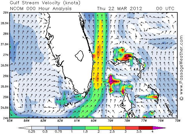
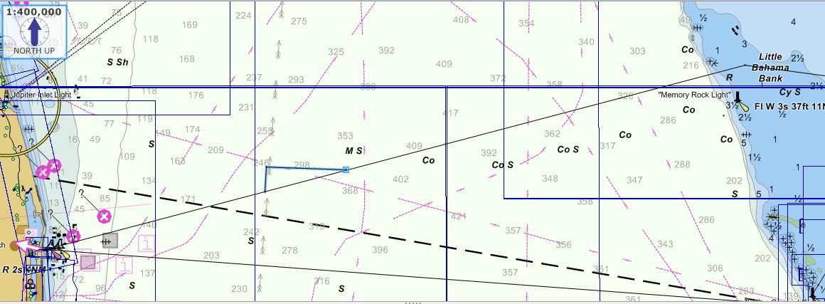
Crossing the Gulf Stream worries some people. It should if you have a wind from the north since the seas will stack up with the wind against the current. However, when the wind is down and from the south then it isn't that bad. The website that I use to get Gulf Stream information is Passage Weather website. Specifically, the link is: http://www.passageweather.com/ If you look to the right, you will see the prediction for the Gulf Stream currents for March 22, 2012 For the most part we will be in the yellow, however, you can see that as you get closer to the Bahamas the stream has less current. So I used a current of 1.75 knots for the planning right now. This will change as we get closer and I'll re-do the vector diagram. In the screen shot below, I show you the Track we will be following along with two vectors. The actual track is for 75 degrees True. You can see the arrow indicating the current direction that is printed on the chart. Next to that you can see two lines. The vertical line is for the current of 1.75 kts and the almost horizontal line is the course we have to steer with a boat speed of 5.7 knots. The direction of the line gives us Course to Steer which is 92 degrees True and based on the Variation, 99 degrees Magnetic. Since everyone has a different deviation (due to magnetic disturbances on Your boat) then I can't give you the actual Compass heading to steer. Let's just call it 100 degrees on the compass and we will correct as we get closer to Memory Rock Light. The bottom line is that I will probably change my GPS so it shows True for the crossing then I won't have to worry about the corrections. As for what Speed we will make Good, it will be 6 knots. Next up, why did we go north of Memory Rock? |
 |
 |
|
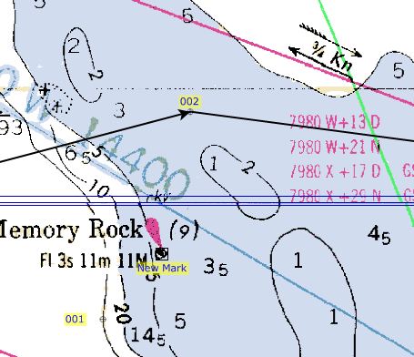
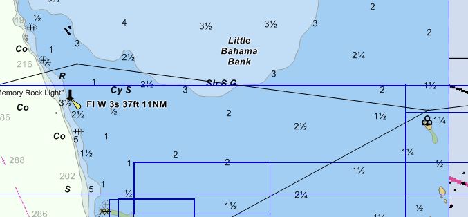
After we are across the Gulf Stream we will be going onto the "bank." Water is much shallower as you can see from the screen shot to the right. The depths are in Meters on this chart so I decided that we would go to the north of Memory Rock in what is charted about 8-9 feet of water. We could have probably cut between the smaller opening but no sense making someone with a deeper draft get concerned. Also, in the Explorer Charts it shows a route that is also a bit further south. At this point, not knowing who is actually going with us, I thought for planning purposes we would just add 2 miles to the trip and choose the deeper water. We may change that when we know exactly who is going along. From this point, we will turn and head for Mangrove Cay. As you can see in the chart to the right we will either have a current with us or against us depending on tides. It is my plan currently that we anchor for the night at Mangrove Cay. As you can see below, we have intercepted the route I took a few years ago when we were in this area before. The mileage for the day will be about 80 nautical miles. So it will probably be a pretty long day. 80 nm at 6 kts will work out to about 13.3 hours but we all know it will be longer based on tides. If we start at 4:30 am then we should clear Memory Rock mid afternoon and should be anchored before sundown. Depending on how everyone feels, we may even decide to extend the day on to Great Sale which would be another 21 nm. We can play that by "ear." Two days later we should be checking in at Spanish Cay. |
 |
 |
|
Web Page by Jim Faughn